
Will El Niño save us? Don’t count on it
Weather forecasting is nebulous at best according to Chris Smallcomb, Warning Coordination Meteorologist at the National Weather Service in Reno. Smallcomb made a presentation about Extreme Weather and the Drought of 2013-2014 at the third Sierra Nevada Aquatic Research Laboratory (SNARL) lecture of the season on Tuesday night at the Green Church.
“It’s appropriate we’re talking about drought on a rainy day,” said Dan Dawson, SNARL’s Director, before handing the microphone to Smallcomb.
“Drought is not just a short term thing,” Smallcomb began his presentation. “It’s very much a long term thing.”
A “meteorologist and weather geek at heart,” Smallcomb is his office’s primary outreach coordinator, working with the emergency management and the public safety community on weather preparedness and briefing on major storms. He was personable, witty, and made the audience laugh throughout his pessimistic presentation of drought conditions (which was interesting, because he’s a self-described optimist).
Smallcomb explained that much of modern development in the western U.S. has occurred in the wetter climates of the last 200 years. This makes the sustainability of the west dependent on wetter weather patterns, despite historic periods of dry weather. Pointing to evidence of ancient tree trunks in both Walker River and Tenaya Lake, Smallcomb said there have been periods of 100 to 140 year mega-droughts in our region.
This led the speaker to his first question: Are we changing to a drier pattern or not?
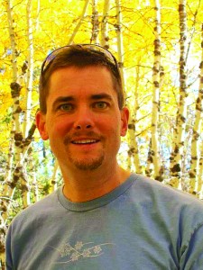
Chris Smallcomb.
“The drought didn’t just happen but has been building and growing over the last 5, maybe 10 years,” Smallcomb said. “And the drought conditions have been unusual and very intense.”
Smallcomb and his office work with Drought Monitor, a collaborative group of public and private agencies that has looked at weekly precipitation deficits, impacts, snow conditions, assessing the status of drought over the last 14 years. Smallcomb said this year’s drought is “the worst of the worst… dare I say an almost Dust Bowl-type drought.”
Presenting graphs of both Lee Vining and Bishop over the past three winters, Smallcomb showed a structural deficit in precipitation throughout the region. “We’re missing an entire year’s precipitation,” Smallcomb said. Drought conditions are “not likely to be cured in one winter season. It’s going to take a couple of decent winters to dig us out of this deficit”
The winter of 2013-2014 winter is in the top 10% of dry winters and also the top 10% of warmest winters, seeing low precipitation levels between October and March when the region usually gets 60 to 80% of its yearly precipitation.
Next question: Why has it been so dry?
Similar to the weather patterns of the benchmark 1976-1977 drought, there has been blocking bridge of high pressure sitting off the California coast that pushes the jet stream and therefore the storm track further north up into British Columbia. Although these systems can be common, this year they have “persisted for weeks if not months” according to Smallcomb. These high pressure systems are not only responsible for pushing storms north, but also for the low pressure systems east of us, causing the polar vortex winter conditions on the east coast.
“The deflecting jet stream and storm track robbed us of our chance for moisture-laden storms,” Smallcomb said. “We don’t know why this is happening. There’s speculation, but there is nothing definitive or research to prove it.”
Smallcomb said he’s met people from Vancouver who complain about how it rained all winter. “They basically stole all of our water,” Smallcomb said. “Blame them.”
These weather patterns have affected local snowpack, as snowfall has been limited to higher elevations of 7,000 to 8,000 feet. and higher. “It’s shocking how little [snow] there is,” Smallcomb said of the April 15th readings.
Below these elevations, precipitation has fallen as rain but rainfall measurements can be deceptive. The snowpack affects water supplies for the succeeding seasons, whereas rainwater is absorbed directly into the soil. “There’s no snow to melt off,” Smallcomb said. “Its safe to say we can give it a grade of F. ”
“So does the drought change our extreme weather?” Smallcomb next asked rhetorically.
“We already live in an extreme area,” he said. “The drought could make things potentially more extreme in some respects.”
Based upon the last several years, Smallcomb said there have been fewer winter storms, storms are at higher snow levels, and we’ve had shorter winter seasons.
Smallcomb said this creates adverse conditions for the upcoming fire season, as vegetation, particularly old growth trees, are drying up and even dying, creating ample fuel for forest fires. The dry ground also contributes to the rising heat, which destabilizes the atmosphere and creates more thunderstorms. “If the ground and vegetation aren’t as moist as they should be, the sun’s energy just goes into heating the atmosphere,” Smallcomb said. “It’s just basic physics.”
Smallcomb warned the audience that even if we do see a lot of rain this summer, it doesn’t mean we are out of the red. Precipitation in the winter, contributing to snowpack is what’s important, and we can’t get complacent about the drought now. “Drought is a creeping hazard. It doesn’t strike like a tornado,” he said. “The longer the drought keeps going, the more severe it will become.”
Which led to the big question of the night: Will El Niño save us?
“It’s hard to predict the start of a drought,” Smallcomb said. “But it’s darn well impossible to predict the end.” He also warned that droughts usually end in floods, citing 1997 and 2005 as examples.
Smallcomb presented data that favors the odds of an El Niño winter at 80% to La Niña conditions (3%). But he also said that weather forecasters can really only tell general trends out to about 14 days: “Past that, I don’t have a lot of confidence.”
If we do see El Niño conditions towards the end of this year, it almost guarantees a wet winter in Southern California, Arizona and Southern Nevada, but the correlation between a strong El Niño year and precipitation levels in the Eastern Sierra “is much more nebulous,” Smallcomb said. “We could have a wet winter, we could have a dry winter during an El Niño.”
Smallcomb concluded that the drought is going to persist, if not intensify, this calendar year affecting our wildfire season and water supply. And even though El Niño is likely next winter, the strength and impact on the Eastern Sierra is still uncertain.
“I wouldn’t put a whole of stock in El Nino predictions” Smallcomb said. “It’s highly unlikely to end the drought.”


